Some of the links in this article may be affiliate links. If you make a purchase through these links, we may earn a small commission at no extra cost to you. Thank you.
Rating geocache difficulty correctly comes down to two separate questions: how hard is it to find the cache, and how hard is it to physically get there? The first is your difficulty rating. The second is your terrain rating. Get both right from the start, and finders arrive prepared, have a great experience, and leave positive logs.
Thank you for reading this post, don't forget to subscribe!
If you have ever read a geocaching log saying “this was way harder than a D2 suggested” or “the terrain nearly wiped us out for a T2 listing,” you already know why accurate ratings matter. Geocaching.com hosts more than 3 million active caches across 190+ countries, and the difficulty-terrain (D/T) rating system is the universal language every cache owner uses to set seeker expectations. Get the rating wrong, and frustrated finders follow.
This guide covers everything — what each star level actually means, how to work through the official rating matrix step by step, the most common mistakes to avoid, and practical advice from the geocaching community to help you nail your rating the first time.
Key Takeaways:
- Difficulty = the mental or puzzle challenge of finding the cache; Terrain = the physical challenge of reaching it.
- Both attributes use nine possible values from 1.0 to 5.0 in half-star increments.
- Geocaching.com’s official D/T rating matrix — developed by community volunteer Clayjar — gives cache owners a structured, bias-free framework for accurate ratings.
- Always rate from the perspective of an average adult geocacher, not from your own perspective as the person who hid it.
What Does the Geocache Difficulty Rating System Actually Mean?
The geocaching difficulty-terrain (D/T) rating system gives every cache two independent numbers that work together to tell finders exactly what to expect. These are written in the format D2/T3, meaning Difficulty 2, Terrain 3. Every cache published on Geocaching.com requires both attributes before a volunteer reviewer can approve the listing — they are not optional fields.
The scale runs from 1 (easiest) to 5 (most challenging), with half-star increments in between. That gives you nine possible values per attribute: 1.0, 1.5, 2.0, 2.5, 3.0, 3.5, 4.0, 4.5, and 5.0. You assign both a difficulty score and a terrain score completely independently when you submit a cache for review.
Here is what matters most to understand: difficulty and terrain are entirely separate measurements. A cache can be D1/T5 — trivially easy to find once you are there, but requiring a boat or technical climbing gear to reach. Conversely, a D5/T1 cache might sit right next to a paved parking lot but require expert-level cipher knowledge to locate. Treating these two ratings as separate questions is the foundation of the entire system.
According to Geocaching.com’s official hide guidelines, ratings should always reflect the experience of a competent, reasonably fit adult geocacher with a standard GPS device — someone who has found a few dozen caches and understands common hide patterns, but who has no prior knowledge of this specific listing. Not a beginner. Not an expert. And critically — not the cache owner who already knows exactly where it is hidden.
What Is the Difference Between Difficulty and Terrain Ratings?
This is the single most misunderstood aspect of the geocaching rating system — and even experienced cachers occasionally blur the line. The cleanest way to remember it: difficulty is about your brain, terrain is about your body.
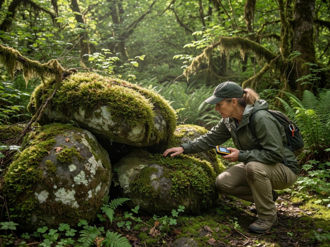
Difficulty measures how hard it is to physically locate the cache container once you are at or near ground zero (GZ). It includes how well the container is camouflaged, whether finding it requires puzzle-solving or specialist knowledge, whether specific tools are needed, and how long a competent finder typically takes to complete the locate. A nano cache painted to match a metal sign is harder to find than a large Tupperware tucked under a log — even if both caches sit at the exact same GPS coordinates.
Terrain measures how physically demanding it is to travel to and from the cache location. Think: distance from the nearest parking area, elevation change, surface type, trail conditions, obstacles, and whether specialized equipment is required to even reach the spot. According to Geocaching.com’s official listing guidelines, a Terrain 1 cache must be fully accessible to wheelchairs without any assistance — flat surface, no steps, no uneven ground, and within approximately 100 meters of a vehicle. A Terrain 5 requires specialized equipment most people do not own: scuba gear, technical climbing harnesses, or a watercraft.
Keeping difficulty and terrain on completely separate tracks — even when one influences the other in practice — is what makes the rating system genuinely useful. A physically demanding approach to an easy-to-find container should produce something like D1.5/T4, not a blended middle number across both attributes. The two scores tell very different stories to finders, and both stories matter.
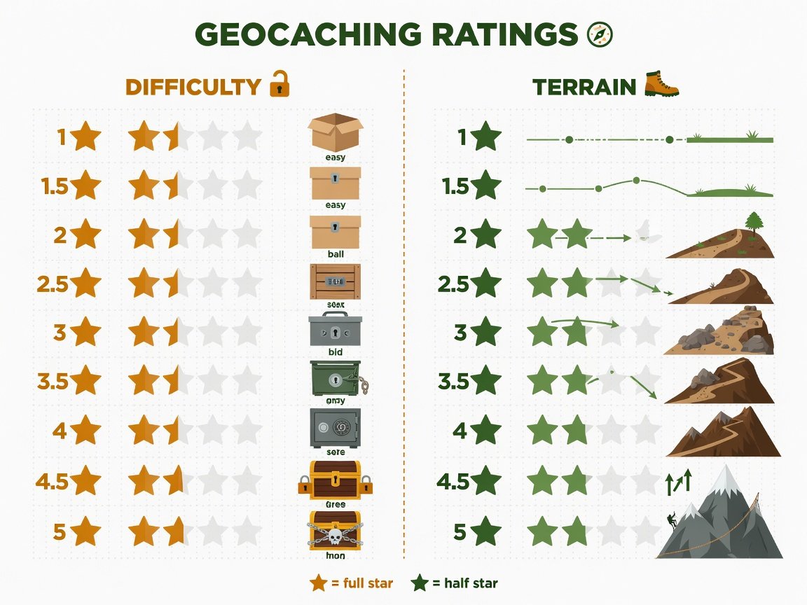
How Does the 1–5 Star Rating Scale Work for Each Attribute?
Here is a full breakdown of what each star level means for both difficulty and terrain. Use this as your reference baseline when assigning ratings before you submit a cache for review.
| Rating | Difficulty (Finding the Cache) | Terrain (Getting There) |
|---|---|---|
| 1 | Very easy. Any geocacher finds it quickly. No special skills needed. Ideal for first-timers and families. | Accessible to all, including wheelchairs. Flat, paved or compacted path. Under 0.5 km from parking. |
| 1.5 | Easy with minimal searching. Container is obvious or visible once in the correct area. | Easy walking on slightly uneven surfaces. Suitable for young children and all fitness levels. |
| 2 | Some searching required. May need to look from different angles or read a hint carefully. | Moderate walking on unpaved or gently uneven terrain. Short distances, no major obstacles. |
| 2.5 | Moderately challenging. Container is well-hidden; average finder may take 15–30 minutes. | Some hills, roots, or rough trail surfaces. Comfortable footwear strongly recommended. |
| 3 | Challenging. Good camouflage, creative placement, or non-obvious thinking required. 30+ minutes typical. | Significant elevation, dense vegetation, or off-trail navigation required. Not suitable for casual walkers. |
| 3.5 | Quite challenging. Experience with unusual hide types or specialized observation skills helpful. | Difficult terrain involving scrambling, minor rock climbing, or bushwhacking. |
| 4 | Difficult. Special tools, night-only access, complex puzzle-solving, or multi-stage research required. | Very challenging. Technical hiking, waterproof boots, trekking poles, or wading likely required. |
| 4.5 | Very difficult. Extensive research, rare specialist knowledge, or significant field expertise needed. | Climbing gear, kayak, or other specialized approach equipment required. |
| 5 | Expert level. May require cipher expertise, scuba access, team coordination, or rare specialized skills. | Requires specialized equipment — scuba gear, technical ropes, or a sustained multi-day approach. |
These descriptions are guidelines, not hard rules. Geocaching.com’s official D/T rating matrix — originally built by community volunteer Clayjar and used as the basis for reviewer guidelines — breaks these categories down into specific yes/no checklist questions, making the process far more objective than trying to match a vibe-based description. More on how to use that matrix below.
How Do You Rate Geocache Difficulty in 5 Steps?
Rating difficulty honestly requires stepping outside your own knowledge and thinking like a finder who has never seen your hide. Here is a reliable five-step process used by experienced cache owners to calibrate their ratings accurately before submitting.
- Imagine a competent adult finding it cold. Picture someone with standard geocaching experience, a GPS or smartphone app, and no hint. How long do you realistically think it will take them to find the container? Under 5 minutes points to D1–D1.5. Around 10–20 minutes suggests D2–D2.5. Consistently over 30 minutes for experienced finders indicates D3 or higher.
- Assess the quality of the camouflage. How well does the container blend with its surroundings? Consider visibility from standing height, from ground level, and from multiple angles — most experienced hunters check all three. A container indistinguishable from its environment at a distance of 1 metre rates significantly higher than one that catches the eye immediately.
- Identify any prerequisite knowledge or puzzle-solving. Does the finder need to solve a cipher before leaving home, research a local landmark, count architectural features, or apply knowledge from a specific field? Any meaningful prerequisite bumps difficulty up. Puzzle caches requiring advance research or solving are typically D3 at minimum and often D4 or higher.
- Check for required tools or techniques. Does finding the container require a UV flashlight, a strong magnet, a mirror, a specific app, or any equipment beyond a standard GPS device? Per Geocaching.com’s official guidelines, if specialized tools are required — not just occasionally useful — that should push difficulty to at least D3.5. Many tool-dependent hides sit at D4.
- Get a test finder before you submit. Ask a fellow geocacher who has not seen the hide to go find it cold. Time them. Note whether they needed the hint and how much of it they used. Real-world feedback from a naive finder is the single most reliable rating calibration tool available. One honest test finder is worth more than a hundred theoretical estimates by the cache owner.
A quick ongoing reality check: if your D3 cache is consistently generating “easy find!” logs from cachers with 500+ finds, the real rating is likely D2. If your D2 is producing logs that say “spent 45 minutes and needed the full hint,” bump it up. Your find logs are live calibration data — pay attention to them and update your rating when a clear pattern emerges.
How Do You Rate Geocache Terrain in 5 Steps?
Terrain rating is generally more straightforward than difficulty because it is based on observable, physical factors. The primary challenge is honest self-assessment — especially for active, fit cache owners who may underestimate how demanding an approach actually is for the broader caching population.
- Measure the total round-trip distance from parking. Distance alone does not define terrain, but it is a strong baseline factor. A cache within 100 metres of a vehicle access point starts at T1–T1.5. Anything requiring more than 5 km of total hiking typically falls in the T3.5–T4+ range, depending on surface type and elevation change.
- Evaluate surface type and condition. Paved paths, compacted gravel, and level ground point toward low terrain. Rocky trails, dense undergrowth, steep slopes, river crossings, and loose scree point toward higher terrain. Ask yourself: could an averagely fit adult in trainers manage this approach safely? If not, terrain is T2.5 or higher.
- Check wheelchair and mobility accessibility with care. Geocaching.com specifically ties the wheelchair-accessible attribute to T1 listings. Only assign T1 if the route is genuinely flat, smooth, unobstructed, and within easy range of vehicle access. A single unexpected step, curb, or rough patch invisible in the listing can make T1 inaccurate for users who depend on that flag — and that causes real problems.
- Identify non-negotiable equipment needs. Does reaching the cache require a boat, kayak, scuba gear, climbing harness, ropes, or snowshoes? If any piece of equipment is required — not just helpful — reflect it in both the terrain score and the listing attributes. Most equipment-dependent caches are T4.5 or T5. Be specific in your description about exactly what is needed.
- Account for seasonal and weather-driven changes. A cache that is T2 in summer may be T4 in winter due to snow, ice, or trail flooding. Rate for the hardest conditions your listing will realistically face year-round, or clearly note seasonal variation in the cache description. Adding attributes like “may require specialized equipment in winter” helps finders self-select appropriately.
Community feedback from experienced Geocaching.com reviewers consistently shows that terrain is more often underrated than overrated. Cache owners tend to be active, fit outdoor enthusiasts — and what feels like a casual stroll to them can be a genuine challenge for a casual day-tripper, an older cacher, or a family with young children. When you are on the fence between two terrain levels, the community-conscious choice is to round up.
What Is the Official Geocaching D/T Rating Matrix and How Do You Use It?
The most reliable tool for rating a geocache accurately is the official Difficulty/Terrain rating matrix — originally developed by geocaching community volunteer Clayjar and formally referenced in Geocaching.com’s cache review process. Rather than relying on gut feeling, the matrix guides you through a series of yes/no questions for both attributes and tallies a score based on your honest answers.
The matrix is available via the Geocaching.com website and several community resource pages. Work through each question from the perspective of an average adult finder — not your own experience as the person who knows where the cache is.
Key questions the difficulty side of the matrix addresses:
- Is the cache very easy for any geocacher to find? (D1 indicator)
- Is the container camouflaged to blend with the surrounding environment?
- Does finding the cache require special tools beyond a standard GPS device?
- Does the cache require research or puzzle-solving before going into the field?
- Is the cache available only at specific times or under specific conditions?
The terrain side covers trail type and condition, total elevation change, distance from the nearest vehicle, whether specialized equipment is required for access, and whether the route is passable year-round. Each “yes” to a harder-condition question shifts your score upward.
The matrix does not guarantee a perfect rating every time, but it dramatically reduces the most common errors. Volunteer reviewers consistently note that the majority of rating disputes they handle could have been avoided if the cache owner had simply worked through the matrix before submitting. It takes under 15 minutes and is worth every second.
What Are the Most Common Geocache Rating Mistakes Cache Owners Make?
Even experienced cache owners get this wrong. Here are the patterns that come up most frequently in find logs and reviewer feedback — and exactly how to avoid each one.
Rating from the hider’s perspective. You know exactly where the cache is. Every hide looks easy when you already have the answer. This is the single biggest source of underrated difficulty across the platform. The fix: always visualize the experience of a finder who has only the coordinates and a hint — nothing more.
Merging difficulty and terrain into one blended score. A long, punishing hike to a container sitting in plain sight should be rated T4/D1 — not T2.5/D2 as a vague compromise. Rate each attribute on its own merits and let the two numbers tell the complete, honest story together.
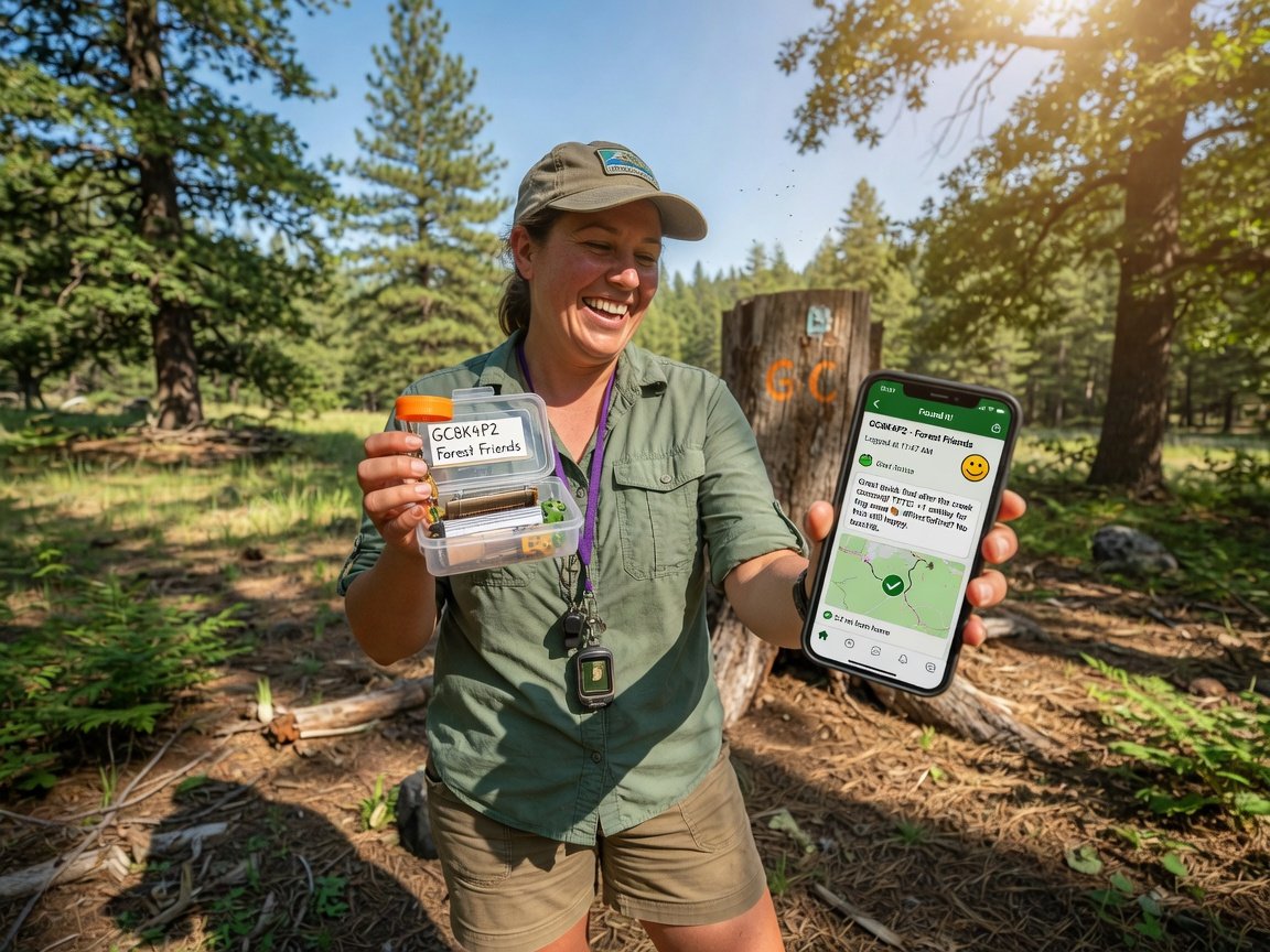
Ignoring find log feedback. Your logs are a real-time rating report card. If cachers with 500+ finds consistently report a cache was much easier or harder than listed, that is meaningful signal. Most cache owners can edit ratings post-publish — and should when a pattern in the logs makes the mismatch clear.
Forgetting seasonal terrain changes. A trail that is T2 in dry summer conditions may be T4 in early spring when runoff floods the path. Rate for the worst reasonable seasonal conditions your cache will face, or add a clear seasonal note to the description along with relevant attributes.
Inflating ratings to seem more impressive. Bumping a cache to D4 when experienced cachers are finding it in under 15 minutes damages your listing’s credibility fast. Let the rating be honest and let the find experience speak for itself.
How Do Accurate Ratings Affect Your Cache’s Long-Term Success?
Accurate ratings are directly tied to finder satisfaction — and finder satisfaction determines whether your cache earns positive logs, maintenance-free longevity, and a healthy find count over time. With more than 6 million registered geocachers on Geocaching.com globally, finders are making decisions about which caches to hunt based on D/T ratings, cache type, and attributes before they ever leave home.
Caches rated D1/T1 consistently receive the highest total find counts — accessible ratings attract the broadest possible audience, including families, beginners, tourists, and urban cachers looking for a quick lunchtime hunt. Higher-rated caches attract a smaller but deeply motivated audience of experienced hunters who often leave the most detailed, enthusiastic logs.
The real problem is always mismatch. When a cache is rated much easier than it actually is, finders arrive underprepared and leave frustrated. When it is rated much harder, experienced cachers skip it expecting a brutal hunt and miss out on what might be a genuinely fun hide. Both scenarios lead to “needs maintenance” flags, negative logs, and a shorter active lifespan for the listing.
Accurate ratings also speed up the reviewer approval process. Geocaching.com volunteer reviewers handle hundreds of submissions, and a rating that clearly mismatches the described hide type triggers additional back-and-forth correspondence that delays publication. Getting it right the first time benefits everyone.
What Do Experienced Geocachers Recommend When Rating Caches?
The geocaching community has built up decades of practical wisdom around rating caches accurately. Here is what consistently surfaces from experienced hiders, active community reviewers, and long-time geocaching contributors.
“Use the official matrix — every single time.” This recommendation comes up universally among veteran cachers and community reviewers alike. As Geocaching.com’s cache review guidance makes clear, the D/T matrix was specifically designed to remove personal bias from the rating process. Even when you feel confident in your instinct, ten minutes with the matrix is always worth it.
“Get a naive test finder before you submit.” Ask a geocaching friend — someone who genuinely has not seen the hide — to go find it cold. Time them and note how much of the hint they needed. This single step provides more accurate calibration than any amount of theorizing by the cache owner. It is the closest thing to a ground-truth rating test the community has.
“Pay close attention to your first ten logs.” The initial wave of finders provides the most unfiltered feedback your listing will ever receive. Multiple finds in the first week all flagging the same rating concern is a strong signal worth acting on promptly. Geocaching.com actively encourages cache owners to update ratings based on community feedback — there is no penalty for making an honest correction.
“When in doubt about terrain, round up.” The geocaching community skews physically active and outdoorsy — what feels easy to a seasoned trail runner can be a real challenge for a casual weekend hiker, an older cacher, or a family pushing a stroller. Erring on the side of a slightly higher terrain rating is the more community-conscious choice.
The most common rating mistake? Judging difficulty by how clever the hide feels from your own perspective as the hider — rather than how hard it actually is to find from the searcher’s perspective.
Geocaching community best practice
Frequently Asked Questions About Rating Geocache Difficulty
Can I change my geocache’s difficulty or terrain rating after it’s published?
Yes — and you should if the log feedback warrants it. Geocaching.com allows cache owners to edit D/T ratings at any time after a listing goes live. Log in to your account, navigate to your cache listing, and update the attributes. There is no penalty for correcting a rating, and the community broadly respects owners who stay engaged with finder feedback and make honest adjustments when the data is clear.
What is the real difference between a D3 and a D4?
A D3 is challenging but findable by a moderately experienced geocacher who takes their time, thinks creatively, and searches carefully — even without needing the hint. A D4 typically requires specialized tools, significant puzzle-solving effort, or research conducted before or during the hunt. Many D4 caches involve UV lights, magnetic retrieval techniques, complex cipher puzzles, or access conditions that limit when the cache can be found. If most experienced finders are needing the full hint on what you rated D3, it may actually be a D3.5 or D4.
How do I rate a multi-cache with stages of different difficulty?
Rate the most challenging individual stage — not the average across all stages. If the final container is an easy D1.5 find but a middle stage requires D4-level cipher work, the overall listing should reflect D4. Finders need to know the hardest challenge they will face during the hunt. Apply the same logic to terrain: use the most demanding terrain any single stage requires, and describe what to expect at each stage in the cache description so finders can prepare properly.
Should I rate for a complete beginner or an experienced geocacher?
Neither extreme. Rate for an average, reasonably experienced adult geocacher — someone who has found somewhere between 20 and 100 caches, understands common hiding patterns like magnetic nano caches, fake bolts, and camouflaged containers, and is comfortable using a GPS app. Do not rate for a total beginner (that would make most hides D3+) and do not rate for a power-cacher who knows every trick going (that would make most hides D1). The average competent adult baseline is the community standard referenced throughout Geocaching.com’s official guidelines.
Which listing attributes should I set alongside my D/T rating?
Attributes provide important context that D/T numbers alone cannot fully capture. Key ones to consider: “wheelchair accessible” (only if genuinely T1), “available 24/7” or “available at night only” (critical for caches with time-restricted access), “requires boat,” “requires swimming,” “requires special equipment,” “recommended for kids,” and “available in winter.” Setting the right attributes alongside an accurate D/T rating gives finders the fullest possible picture before they commit to the hunt — and significantly reduces the chance of anyone showing up underprepared.
What happens if a geocaching reviewer disagrees with my rating?
Reviewers will contact you before approving the listing if the rating seems significantly inconsistent with the cache description, hint, or hide type. They may ask you to reconsider a specific attribute or provide more detail. This is a completely normal part of the submission process — not a rejection. Geocaching.com’s volunteer reviewers are experienced cachers who handle these conversations regularly and are genuinely helpful about explaining community standards. Most rating discussions resolve with a quick adjustment, and the cache goes live shortly after.
Start Rating With Confidence: Your Next Steps
Accurate difficulty and terrain ratings are one of the most generous things you can do for the geocaching community. They set honest expectations, help finders show up prepared, and create the conditions for a genuinely great experience — which is, ultimately, why most cache owners place hides in the first place.
Here is a clear action plan to apply everything in this guide:
- Before you submit (today): Open the official Geocaching.com D/T rating matrix and work through both the difficulty and terrain question sets honestly. Budget 10–15 minutes for this step.
- Before the listing goes live: Ask a geocaching friend to test-find your cache cold. Time them and note hint usage. Adjust your rating based on the real-world result — this single step catches more rating errors than anything else.
- Within the first month: Read your first 10–15 find logs carefully. If multiple experienced finders flag a rating concern, update the attribute in your listing. No penalty, and the community appreciates the transparency.
- Each season: Revisit your terrain rating if your cache location experiences significant seasonal changes. Update attributes as conditions warrant and add a seasonal note to the description if needed.
- Ongoing: Check back on your listing every few months. A cache that was accurately rated when placed may need an update if the environment changes, vegetation grows in, or a nearby landmark used in the hide is altered.
The geocaching community at Geocaching Today has plenty more resources on placing, rating, and maintaining caches of every type and difficulty level. Whether you are preparing your very first hide or refining your tenth, accurate ratings are the foundation of a listing that finders will enjoy — and return to — for years to come.
—