Some of the links in this article may be affiliate links. If you make a purchase through these links, we may earn a small commission at no extra cost to you. Thank you.
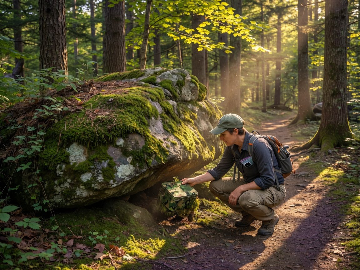
You can legally hide geocaches on public land, private property, and select federal land — but only when you follow the rules set by the land manager and geocaching.com’s official guidelines. The short answer: always get permission first. Whether you’re hiding your first cache or your fiftieth, understanding exactly where placement is allowed protects you, protects the hobby, and ensures your hide stays active for years to come.
Thank you for reading this post, don't forget to subscribe!
With more than 3 million active geocaches spread across 190+ countries, geocaching is one of the fastest-growing outdoor recreation activities in the world. But not every cache is placed correctly. Improper placements get archived, damage the hobby’s reputation with land managers, and can even result in fines. This guide covers every legal placement option — from city parks to national forests — so you can hide with confidence.
Key Takeaways
- Always contact the land manager or property owner before hiding — permission is required in virtually every jurisdiction.
- Geocaching.com enforces a 528-foot (161-meter) minimum separation between cache listings.
- National parks have restrictive and inconsistent geocaching policies; national forests and BLM land are far more permissive.
- Certain zones — archaeological sites, sensitive habitats, and active construction areas — are always off-limits.
- A well-placed, legal cache can stay active for 10+ years and become a genuine community landmark.
What Does It Mean to Hide a Geocache Legally?
Hiding a geocache legally means three things: you have permission from the land manager or property owner, your cache follows geocaching.com’s listing guidelines, and your placement doesn’t violate any local, state, or federal regulations. Miss any one of these, and your cache is at risk of being removed — sometimes permanently.
Geocaching.com, the world’s largest geocaching platform, acts as a first layer of review through its volunteer reviewer network. Reviewers check that your listing meets platform rules before it goes live. But they can’t physically inspect every hide, which is why land manager permission and honest cache descriptions matter so much.
According to geocaching.com’s published guidelines, cache owners are responsible for obtaining permission from land managers before submitting a new listing. The platform reserves the right to archive any cache where permission cannot be verified. In practice, this means you need documentation — an email reply, a signed permit, or a reference to a published policy that explicitly allows geocaching in that specific area.
For a thorough look at what that documentation looks like across different land types, the permission and placement rules for legally hiding a geocache covers exactly what to say when you contact a land manager for the very first time.
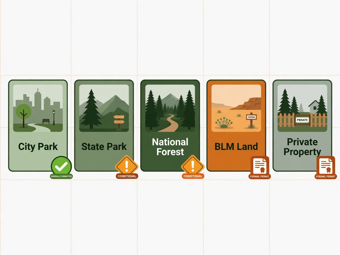
Which Public Lands Welcome Geocaches?
Public land is the most common place to hide a geocache, but “public land” covers an enormous range of land types — and each carries its own rules. Here’s how the main categories break down.
City and Municipal Parks
Most city and county parks allow geocaching, and many actively encourage it as a way to drive outdoor recreation engagement. Your local parks and recreation department is your first call. Some cities run formal geocaching permit processes; others simply ask for a brief written heads-up. A 2023 survey by the American Recreation Coalition found that over 60% of municipal park systems in the United States had geocaching-friendly policies already in place, with most requiring nothing more than a simple written request submitted by email.
When you contact your local parks department, be specific. Include the proposed GPS coordinates, the container type and approximate size, how it will be camouflaged, and a maintenance schedule. Land managers are far more likely to approve a detailed, thoughtful request than a vague one.
State Parks
State parks vary dramatically. Some state park systems have developed official geocaching programs complete with designated hiding zones and self-service permit applications. Others require a formal proposal and review process. A handful still prohibit geocaching entirely — particularly in wilderness zones or ecologically sensitive areas. Before placing anything in a state park, visit the park’s official website and search for geocaching-specific policies. If you can’t find a policy, email the park manager directly and keep that reply as your proof of permission.
Bureau of Land Management (BLM) Land
BLM land is generally very geocaching-friendly. The Bureau of Land Management oversees approximately 245 million acres across the western United States and actively supports low-impact recreation activities including geocaching. In most cases, casual recreational geocaching on BLM land doesn’t require a formal permit — but you should still contact the relevant field office if your cache will be permanent or located near a sensitive resource area.
National Forests
The USDA Forest Service manages 193 million acres across 154 national forests and generally permits geocaching under its non-motorized recreation policies. Most individual forests don’t require a permit for small, non-commercial geocaches. Special areas — wilderness zones, designated research natural areas, and riparian conservation areas — may have additional restrictions. Always check with the specific ranger district before hiding in a national forest, and document the response.
Can You Hide Geocaches in National Parks?
This is where things get complicated. National parks are managed by the National Park Service (NPS), and each park sets its own geocaching policy. There is no single NPS-wide rule that uniformly allows or prohibits geocaching across all units.
Some national parks — including Gettysburg National Military Park and select others — have developed formal geocaching programs with designated cache sites managed in direct cooperation with geocaching.com. Others actively prohibit all cache placements to protect sensitive habitats and visitor experience. A 2022 NPS internal review found that fewer than 30% of national park units had any written geocaching policy, leaving most in a gray area that defaults toward “contact us first.”
The safest approach: assume you need permission, contact the park’s resource management office directly, and never place a cache in a national park without written approval. Placing an unauthorized cache in a national park can result in removal, fines, and a lasting black mark on the hobby’s relationship with that park unit.
“When in doubt, reach out. A two-minute email to a park manager has saved thousands of geocaches from being archived — and kept the hobby welcome on lands that might otherwise close their doors.”
— Geocaching.com Community Guidelines, Reviewer Best Practices Section
Can You Place a Geocache on Private Property?
Yes — but only with explicit, documented permission from the property owner. Private property geocaches are actually some of the most creative and well-maintained hides in the community. Property owners often become genuinely invested in the cache and help maintain it over time, especially once they discover how many visitors it attracts.
To get permission, identify the owner through your county assessor’s website, then approach them with a clear, friendly explanation of what geocaching is. Tell them what the container looks like, where you’d place it, how you’d camouflage it, and how you’d maintain it. Offer to show them the geocaching.com listing before it goes live. Many property owners say yes when asked respectfully — particularly small business owners and rural landowners who enjoy the foot traffic.
Geocaching.com requires that private property permission be noted in the cache listing, with documentation available if a reviewer asks. A simple email exchange saved to your files is usually sufficient. Update the listing if ownership changes — the new owner may not share the same enthusiasm, and continuing to run a cache on their property without re-securing permission creates real liability.
What Are Geocaching.com’s Official Placement Rules?
Beyond land permission, geocaching.com enforces its own technical placement standards. Every hide must meet these requirements before it goes live — and failing to meet them after publication can trigger an archival. Here are the most critical rules:
- 528-foot minimum separation: Your cache must be at least 528 feet (0.1 miles / 161 meters) from any other active cache listing on the platform.
- No placement near sensitive sites: Caches cannot be placed within 150 feet of documented archaeological, historical, or cultural sites.
- No commercial promotion: You cannot use a geocache to advertise a business or charge access fees without explicit platform approval.
- Maintenance commitment: You must maintain your cache and respond to “needs maintenance” logs within a reasonable timeframe — typically 30 days.
- Safe seeker access: Seekers must be able to reach the cache without trespassing, breaking any laws, or putting themselves in physical danger.
- No proximity to schools or childcare facilities: Caches cannot be placed within certain distances of these locations under community safety guidelines.
These rules apply in addition to whatever the land manager requires. Meeting geocaching.com’s standards doesn’t automatically mean your hide is legal — it means the platform will publish it. Land manager permission always comes first.
How Far Apart Do Geocaches Need to Be?
The 528-foot rule is geocaching.com’s baseline, but some cache types work differently. Traditional caches need to meet the 528-foot minimum from every other cache. For multi-caches, the final stage must meet the distance requirement, while intermediate stages have more flexibility. Mystery or puzzle caches require the posted coordinates to be within 2 miles of the actual final location — and both the posted coordinates and the final must meet proximity rules relative to other caches on the map.
Before you scout any location, pull up geocaching.com’s map view and check existing cache density in your target area. In urban neighborhoods, the 528-foot rule can severely limit your options — it’s common for a promising spot to already sit in someone else’s “radius.” Rural and wilderness areas offer dramatically more placement freedom, which is one reason backcountry hides consistently attract the most dedicated seekers.
Matching the right container to your chosen terrain type is just as important as the location itself. The guide to the best geocache container types for your location walks through which containers hold up in different climates and environmental conditions — from desert heat to Pacific Northwest rain.
Keep in mind that your location will also directly shape your difficulty and terrain ratings. A cache wedged under a boulder on a steep hillside rates very differently from one placed at the base of a park sign. Understanding how location translates into accurate D/T ratings matters — how to rate your geocache hide correctly covers the full rating system so seekers always know what they’re signing up for.
What Locations Are Always Off-Limits for Geocaches?
Some locations are universally prohibited — regardless of who owns the land, what permissions you think you have, or how creative your hide concept is. Geocaching.com will not publish caches in these areas, and attempting to place one anyway risks your account and your relationship with the broader land management community.
| Off-Limits Location | Primary Reason |
|---|---|
| Active military installations | Security risk; federal law restrictions |
| Airport property (runways, taxiways, secure areas) | Aviation security regulations |
| Archaeological and historic sites (within 150 ft) | Risk of disturbance; legal protections under the NHPA |
| Active cemetery sections | Respect for the deceased and mourning families |
| Within 150 feet of railroad tracks | Physical safety hazard for seekers |
| Inside structures where removal causes damage | Property damage liability |
| Posted “No Trespassing” land | Legal and ethical grounds |
| Designated wilderness areas (ground disturbance) | Wilderness Act and environmental regulations |
Beyond this list, apply common sense around environmental sensitivity. Seasonal bird nesting zones, vernal pools, wetlands, and endangered plant communities should be avoided even when they sit on otherwise accessible public land. Geocaching’s long-term access to natural spaces depends entirely on hiders making responsible decisions about where not to hide — just as much as where to hide.
How to Get Permission to Hide a Geocache: Step-by-Step
Getting permission doesn’t have to be a long, complicated process. Follow these steps and you’ll have documented approval for most locations within one to two weeks.
- Identify the land manager. Use your county assessor’s website for private land. For public land, determine which agency manages the specific parcel — city, county, state, or federal.
- Find the right contact person. Most parks and recreation departments have a dedicated contact for special use permits or recreation programs. Email creates a paper trail; use it instead of calling whenever possible.
- Write a clear, specific request. Explain what geocaching is briefly, include the proposed GPS coordinates, describe the container type and approximate dimensions, explain your camouflage approach, and outline your maintenance commitment.
- Offer to share your listing draft. Letting the manager review the listing before it goes live builds trust quickly and often cuts approval time in half.
- Follow up after 10 business days. Land managers are busy. A polite, one-sentence follow-up email is entirely appropriate if you haven’t heard back.
- Document the approval thoroughly. Save the full email thread or scan any signed permit. Upload it to the reviewer notes section of your cache listing so the reviewer can confirm permission without extra back-and-forth.
- Submit your listing with a reviewer note. Include the name of who gave permission, their title, the date, and the method (email, phone, written permit). This dramatically speeds up review time.
Once your cache is approved and live, your job isn’t done. Visit it every three to six months, respond to maintenance logs within a week, and keep your contact details current with geocaching.com. A well-maintained cache earns community respect — and makes every future permission request a little easier. Once the hide is live, a compelling listing description drives traffic to it. The strategies in this resource on writing geocache descriptions that attract more seekers can make a measurable difference in how quickly your cache builds finds and favorites.
What Happens If Your Cache Gets Archived or Removed?
Caches get archived for several reasons: the owner stops maintaining them, a land manager revokes permission, the placement violates a guideline the reviewer initially missed, or the community flags a concern. Being archived doesn’t automatically put your account in jeopardy — but it does pull the cache from active listings and closes it to new finds through the platform.
When geocaching.com archives a cache, you receive a notification explaining the reason. If the issue is fixable — such as needing updated land manager documentation or a maintenance log — you can often petition to have the listing restored once you’ve resolved the problem. The process is straightforward, and reviewers are generally willing to work with cache owners who respond promptly.
Physical removal by a land manager is more serious. Rangers, park staff, and property owners who encounter an unauthorized cache may dispose of it entirely. This damages your relationship with that land manager for all future placements. Repeated unauthorized placements can escalate to a geocaching.com account suspension. The community has a phrase for it — “muggled by a ranger” — and every single case of it is preventable with a simple permission request upfront.
Pro Tips for Choosing a Hide Location That Lasts
The best geocaches do more than exist — they create memorable moments for seekers. Here are field-tested strategies for choosing locations that stand the test of time and keep land managers happy year after year.
- Choose geologically stable terrain. Avoid spots that flood seasonally, erode easily, or see heavy foot traffic from non-geocachers. Disturbed terrain leads to exposed caches and unhappy rangers.
- Think about the “moment of the find.” The best hides reward seekers with a great view, an interesting piece of local history, or a satisfying “aha.” Legal locations and great experiences are not mutually exclusive.
- Scout across multiple seasons before committing. A perfect summer spot can be inaccessible in winter or underwater in spring. Visit your planned location in at least two weather conditions before placing anything.
- Build a realistic maintenance plan. Choose a location you can genuinely visit every three to six months. Remote caches are wonderful, but they demand regular attention. If you can’t commit to the maintenance, the location isn’t right for you yet.
- Consider seeker accessibility honestly. Not every cache needs to be easy — but every cache should be reachable by its intended audience without requiring illegal access or genuinely dangerous conditions.
If you have access to multiple legal locations along a trail corridor or within a park, consider designing a multi-stage experience that guides seekers from point to point across legal terrain. Designing an engaging multi-cache adventure is one of the most creative ways to use geography while staying within every legal constraint — and multi-caches consistently earn higher favorite point ratios than simple traditional hides.
Frequently Asked Questions About Legally Hiding Geocaches
Do I need permission to hide a geocache on public land?
Yes, in almost all cases. “Public land” doesn’t mean “anyone can do anything there.” Every piece of public land is managed by an agency — city, county, state, or federal — that sets specific rules for recreational use. Geocaching is generally treated as a special use activity subject to those rules. Contact the land manager before placing your cache, and get their approval in writing before submitting your listing.
Can I hide a geocache in a national park?
It depends on the specific park. The National Park Service has no single system-wide geocaching policy — each park unit sets its own rules. Some parks run formal geocaching programs; others prohibit all cache placements. Contact the park’s resource management office, explain your proposal clearly, and wait for written approval before placing anything. Never assume that because a cache already exists nearby, yours will be approved automatically.
What happens if I hide a cache without permission?
The most common outcome is physical removal and archival on geocaching.com. On federal land, unauthorized placement can also result in a fine under littering or illegal dumping statutes — fines that can reach several hundred dollars for a first offense. Repeated violations can trigger a geocaching.com account suspension. Beyond the personal consequences, unauthorized caches erode the hobby’s relationship with land managers and make it harder for the entire community to secure future placements.
How close to an existing cache can I hide mine?
Geocaching.com requires a minimum of 528 feet (0.1 miles / 161 meters) between any two active cache listings. This applies to traditional caches and the final stages of multi-caches. Mystery or puzzle caches have additional rules around posted versus actual coordinates. Use the map view on geocaching.com to check cache density in your target area before you invest time scouting a specific spot.
Can I hide a geocache on private property?
Yes, with written permission from the property owner. Identify the owner through your county assessor’s site, approach them respectfully, and explain what geocaching is and what the container looks like. Geocaching.com requires that private property permission be documented and available if a reviewer requests it. If the property changes ownership, you’ll need to re-secure permission from the new owner before continuing to run the cache.
Are there locations that are always off-limits regardless of permission?
Yes. Geocaching.com will not publish caches placed near active military installations, airport secure zones, within 150 feet of archaeological or historic sites, near active railroad tracks, or in legally protected wilderness areas. Some of these are platform policies; others reflect actual federal or state laws that make placement there illegal regardless of who “grants permission.”
How do I find out who manages a specific piece of public land?
For federal land, the USDA Forest Service’s ranger district locator and the BLM’s interactive map are the best starting points. For state land, visit the state’s department of natural resources or state parks agency website. For city or county parcels, your local parks and recreation department handles it. When in doubt, ask an experienced member of your local geocaching community — veteran hiders often know exactly who to contact for any given location in the area.
Is BLM land always open to geocaching without a permit?
Generally yes, for standard small-container hides on open BLM land. The Bureau of Land Management broadly supports non-motorized recreation and doesn’t require a formal permit for most geocache placements. However, Areas of Critical Environmental Concern (ACECs), designated wilderness areas within BLM management, and culturally sensitive sites within BLM boundaries do carry additional restrictions. Contact your local BLM field office if you’re unsure about a specific parcel.
Where to Go From Here
Hiding a geocache legally is genuinely straightforward once you know the process. The steps are consistent: identify who manages the land, contact them for written permission, follow geocaching.com’s technical placement guidelines, and document everything. Do that, and your hide has every chance of becoming a community favorite that stays active for a decade or more.
Here’s a simple implementation timeline to get your first legal hide placed and published:
- Week 1: Scout your location. Note terrain, seasonal access, and existing cache density on geocaching.com’s map. Photograph the area for your listing.
- Weeks 1–2: Identify the land manager and send your permission request by email. While you wait, research container options suited to your environment and conditions.
- Weeks 2–3: Receive permission confirmation (send a polite follow-up at day 10 if needed). Source and waterproof your cache container. Write a draft logbook entry.
- Weeks 3–4: Place your cache. Record precise GPS coordinates. Draft your listing description and submit to geocaching.com with a reviewer note confirming who granted permission and when.
- Ongoing: Inspect your cache every three to six months. Respond to any maintenance logs within seven days. Renew land manager permission annually if the agency requires it.
The geocaching community grows stronger every time a hider does this the right way. Legal placements build trust with land managers, protect access for future generations of geocachers, and create the quality experiences that keep seekers coming back to the app. Your perfect hiding spot is out there — go find it, get the permission, and share it with the world.
—